Specialists in Remote Sensing
for Utility Corridor Applications
| |
| About XP-RS |
| Electric Utility |
| Vegetation Mapping |
| Gas Utility |
| Wind Farms |
| Contact Us |
| Brochures |
| Environmental |
| >>Home |
| WELCOME |
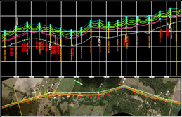
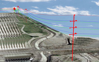
XP-RS is a company that focuses on providing digital mapping and engineering data services for electric and gas utility companies. The majority of its products and services are composed of digital maps, photo & video imagery and databases derived from airborne remote sensing technologies. Although LiDAR is a key component in many projects, XP-RS also utilizes Aerial Photography (orthophotos) Videography and traditional Still Photography to develop high-quality data sets. Geospatial products such as maps and databases are invaluable tools in the effective management and design of utility infrastructures. In addition, the twenty-first century regulatory oversight of FERC and OPS accelerate the need for fast, accurate, reliable (auditable) data. This is our niche! XP-RS specializes in developing data solutions for transmission systems and its geospatial information is targeted at linear corridor applications where accurate mapping is required for the design, construction, upgrade, maintenance & inspection of electric power lines and gas pipelines. The products and services offered by |
XP-RS works with each of its clients to develop and define a scope of work, data acquisition requirements and final data delivery specifications on a case-by-case basis. A USA-based company, XP-RS does not utilize off-shore labor for any of its data acquistion or data processing activities. |
|
| What does XP-RS mean? Our name is pronounced ĭk-sprĕs or (without dictionary speak); Express. Although it's primarily a play on eXPert - Remote Sensing, the spirit of what we do and how we do it is depicted by the common English meanings of the word Express... |
||
|
||
 |
||
Customers Geographic area |
||
|